Forwarding optimization
Create base paths and main base paths
With Dianthus forwarding optimization, you quickly and easily create base paths and main base paths. The program allows you to minimize drive distances and driving damage, while obtaining more accurate data for removal.
- Takes into account timber stock, obstacles, passages, distance, slope and soil moisture
- Calculates average forwarding distances, etc. for e.g. disappearances
- Calculates the amount of wood for each screed (point or line screed) and warns when the felling is filled
- The calculation speed allows for an iterative approach in cases where the user wants to compare the off-road transport distance for different locations of emplacements or alternative base routes/main base routes
- Developed together with SCA as an add-on to ESRI’s product family but can also be used in other environments as the core is written completely independently and without dependencies on other software and license fees

About Dianthus Forwarding Optimization
Suggestions for base roads/main base routes
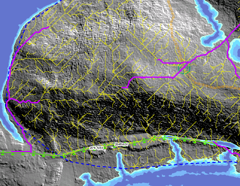
The program makes an intelligent choice of path from each pile of timber out to out to the nearest shed. These forwarding paths are visualized in the map to show the user where it is appropriate to place base paths/main base paths.
Graduation
The user chooses in the map which points and/or line offlays to use. If there are several different fellings, the program automatically selects the best finish for each pile of timber.
The program calculates and shows how much timber goes to each screed and warns if the capacity of an inlay is exceeded.
Obstacles and passages
Forwarding optimization automatically creates obstacles for the forwarding roads if there are roads, paths, ancient monuments or other obstacles in the terrain.
Brook and trail crossings, rolling pin bridges, etc. are used by the program to pass obstacles.
Soil moisture and slope
The program takes into account soil moisture and slope by making it more expensive to drive in these areas.
The costs are different depending on how wet it is and how much it tilts. It is also more expensive to drive in side skids than on a with/against slope.
Available timber
The program retrieves available timber from grids or vector maps with estimated timber volumes.
User interface
A dockable wizard walks the user through the various steps to create a forwarding optimization. For each step there is a clear explanation of what should be done.
Result
Stick roads – the best way from each pile of timber to the screed.
Base roads/main base paths – the stick paths that are used so many times that they are suitable for use as a base road/main base path.
Average sooting distance – and how this is divided between driving in base road, main base path and stick road.
Timber volume – both total timber volume and timber volume divided into different fellings.
Mean output – how much it leans in funds within the calculation range.